
Why GIS and BIM Still Don’t Talk to Each Other, and What to Specify Instead
Most infrastructure organizations now hold both a GIS estate and a BIM estate. The GIS knows where everything is across the network; the BIM knows how each structure is built. On paper, joining them gives an asset owner a single view of the network and its components. In practice the two rarely combine without a project to make them combine, and that project is usually more expensive than anyone budgeted.
The reason is not that the software cannot exchange files. Exports run and geometry appears. The reason is that GIS and BIM were built on different assumptions about what a model is for, and those assumptions survive the export.
This article sets out where the mismatch actually sits, why the usual conversion approach disappoints, and what to write into a specification so the problem does not land on a later budget.
Four mismatches that survive any file conversion
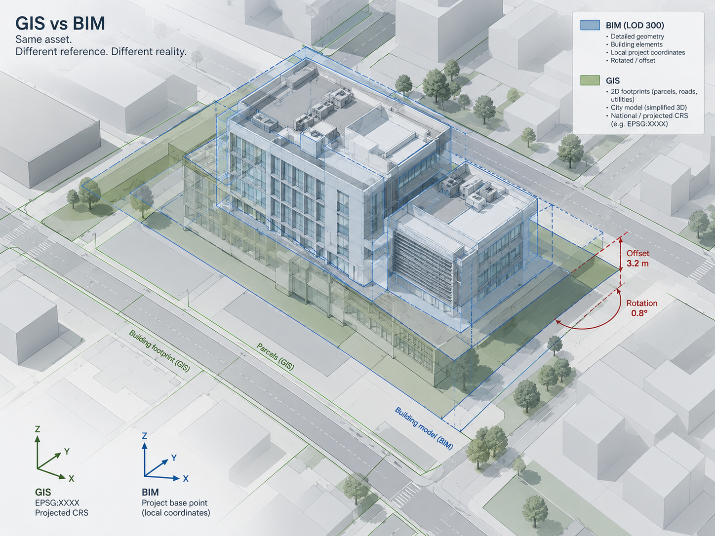
Coordinates. GIS works in projected coordinate reference systems on a curved earth, with defined datums. BIM authoring tools work in a local Cartesian space with a project base point, often set arbitrarily and sometimes rotated for drafting convenience. Converting one to the other requires knowing the base point, the rotation, the elevation datum and the projection — information that tends to live in a modeler’s head rather than in the file. Where a project spans several kilometers, projection scale factor also becomes a real discrepancy rather than a rounding difference.
What an object is. In GIS, a feature is a record with a geometry attached and a well-defined attribute schema. In BIM, an element is a parametric object carrying relationships, materials, host dependencies and a construction sequence. Flatten a BIM element into a GIS feature and the relationships are lost. Push a GIS feature into a BIM environment and it arrives as dumb geometry with no host and no behavior.
Level of detail versus level of information need. GIS scales detail by viewing scale. BIM scales it by project stage and discipline. A model that is right for a design coordination review is far too heavy for a network-wide map, and a network-scale representation is far too coarse for anything a designer needs. There is no single level of detail that serves both, which is why “just load the BIM into the GIS” tends to produce something unusable in both directions.
Time. GIS holds a current state, updated when something changes. BIM holds a design state at a point in the delivery process, with construction sequence attached. Neither is naturally a record of what is there now versus what was there before — which is exactly what an asset owner needs.
Why the conversion-project approach disappoints
The common response is a one-off integration: convert the BIM models into the GIS, or federate them in a viewer. It demonstrates well and degrades quickly, for a predictable reason. The conversion is a snapshot. The next design package arrives with a different base point, a different level of detail and different attribute naming, and the reconciliation work starts again. Two or three cycles later the integrated view is out of date and nobody trusts it.
Organizations that get this right stop treating it as a format problem and treat it as a specification problem. The exchange is defined once, imposed on every supplier, and enforced at the point of delivery.
What to specify
These belong in the tender, not in a later data-migration project:
- A single coordinate reference system for the whole program, named explicitly with its EPSG code, plus the vertical datum. Require every BIM deliverable to state its base point, rotation and elevation offset in that system, in a survey-signed document rather than in the model file alone.
- An attribute schema you define, not one inherited from whichever authoring tool the designer prefers. Name the fields, the units, the permissible values and which are mandatory. Classify by an established system rather than by free text.
- Level of information need per use, stated per deliverable. What must the model support — network mapping, clash detection, quantity take-off, maintenance access, condition recording? Specify to that, and accept that different uses need different representations of the same asset.
- Open exchange formats alongside native files. IFC for the structure and building models, and OGC formats such as CityGML or 3D Tiles on the geospatial side. Native files are still needed for design work; open formats are what survives a supplier changing their software.
- A measured basis. Where the models will be joined to the real world, the tie is a surveyed one. Reality modeling and survey-grade geospatial capture provide existing-condition geometry that both estates can be referenced to, with a documented accuracy statement.
- Acceptance criteria and a validation step. A deliverable that does not load into the target environment, or that fails the schema check, is not accepted. This single clause prevents most of the downstream cost.
- An update path and an owner. Who re-issues the integrated view when a new package lands, on what cadence, and which of the two estates is authoritative for each attribute.
The last two are what separate a working integration from a demonstration. A federated environment with no named owner and no acceptance gate decays into an expensive screenshot.
Frequently Asked Questions
Do we have to pick one — GIS or BIM?
No, and trying to is usually the wrong instinct. They answer different questions and both estates have legitimate owners inside the organization. What needs to be single is the coordinate reference, the classification and the attribute schema — not the platform.
Is IFC enough on its own?
IFC addresses geometry and object semantics between BIM tools. It does not reliably solve georeferencing in practice, nor the GIS side of the exchange. It is a necessary part of the specification, not the whole of it.
We already have years of models with inconsistent base points. Is that recoverable?
Usually, but it is survey work rather than software work: each model has to be tied to control and its transformation documented. Worth doing once, and worth preventing from recurring by fixing the specification before the next package is commissioned.
Where does a digital twin fit?
A twin is the consumer of this, not the solution to it. A twin built on two estates that do not reconcile inherits the problem and adds a maintenance obligation on top of it.
Our Capabilities
- Geospatial Data Services & Remote Sensing — geodetic control, precise survey, GNSS, UAV and satellite-based monitoring.
- Reality Modeling — geometric baselines and epoch-to-epoch change detection on structures and terrain, Scan-to-BIM, Digital Twin Development.
Contact ARGO-E to review your data specification before the next design package is commissioned, so the integration cost does not arrive with it.